Friday, January 6, 2017

When mud is in the name

I really like hiking in places that are close to home. Mud Springs (in southwest Colorado) doesn’t look like much when you get to the trailhead. But the parking lot is big and the road there is paved so I can get there in my little car while the high country is covered in snow.
View from the parking area makes it look flat and boring.
The map is intriguing though. It has these areas that are shaded in that say “Free travel play areas”. Which sounded pretty exciting. Like maybe there would be rope swings.

Those of you familiar with ATVs and rock crawlers probably know where this is going. But as an ever-hopeful hiker that sometimes takes thing too literally and tends to not know a lot about motorized things, I made a beeline to find out what the "play areas" would hold.
Trailhead map
"Free Travel Play Areas"
A road begins from the trailhead. Muddy this time of year. Mud is in the name though, right? At least it’s honest.
Walking in the snowy part of the road
Turning down the muddy trail. Can't avoid it now.
Views into McElmo Canyon and far away to Mesa Verde.

After crossing the canyon, climbing up to the rim with a nice view of Sleeping Ute Mountain.

I head off trail and find some graffiti from 1923. Which makes it a historic inscription.
A cool tree. No rope swing here either though.
The mud is so slippery it’s hard to stay upright. Feet seem to slide in all directions, except forward. Each step is a challenge. Maybe this sliding around is really playing in the mud. Which is alright.
Sticky
Techniques for hiking in mud vary. One main thing is not tiptoeing around the edges— that just widens the trail. Better to plow right into the middle of things. Embrace it. Become one with it.
When I finally get near one of the "play areas" there is some of this. And also a lot of ATV tracks. Still, it's nice to just wander around and see what there is to find.
Did I cover all the ground? This helped me keep track. Sort of fun.
More information
BLM's Mud Springs

Thursday, January 5, 2017

Snyder Ridge Jungle Gym

Found some trip reports I never got around to posting from last year...

Tired of the crowds in Glacier National Park and looking to add some gymnastics to your hiking experience?  Try the Snyder Ridge Fire Trail in early season.

Others have called this a “poorly maintained trail through a wooded ridge with limited views” which is true. But where else can you have the trail all to yourself in Glacier (at least without a ford)?
A series of single blowdowns of varying heights provide a warm up on the climb to the ridge. 
First you have to find the trailhead.  You won’t see the sign from the road unless you look deep in the shadows. There is no parking area, just a turnoff on the other side of the road and the sign hiding in the trees.
A few triples. You can almost get a rhythm going if you get a running start.
All quiet going through massive groves of old-growth cedar.
Rest at the view-through-the-trees once you gain the ridge
Along the top, extensive areas of forest along the ridge were upturned. The trail here is completely covered by a huge tangled jungle gym of stacked-up downed-trees. I suspect it was recent, since there was no sign anyone had been this way- no footprints, no broken branches.  Maybe sometime it will get cleared?
Tangled
The forest is an endless abyss of disorienting branches that attack with their stabbing and jabbing and snagging. 
Then a clear part. It's enough to get your hopes up that maybe it won't be so hard the entire way.
Then more of this.
After a while, when you give up on thinking of this as a walk and give into the reality, try imagining you are still a kid, climbing up and over and around and through the tangled trees and pretend you are having fun. Work on balance beam moves. 
Some trees are so big that have to launch yourself up to get up on top of them.
More excitement: Climb to the top of the heap of broken up trees, and scan the area as far as you can see for some sign of where the trail might go.  Did you forget which way you were going when you were climbing up and over and through, trying not to plummet into the sea of sticks and needles? 
Navigating the playground is not a walk in the park.  Over seven miles of gymnastics is exhausting.  Especially when you get turned around and end up going the wrong direction for an hour.

Did that just happen?  An entire hour of not once checking map, compass or Gaia GPS?  Not once looking up to see the mountain peaks on the wrong side? Not even looking at the cell phone!

When’s the last time *anything* has been that engaging?
Close up view of beetle galleries.
The state of exhaustion is reached. The idea of turning around and hiking through that mess again seems completely crazy. 

It’s OK to bail.  The Lincoln Creek Trail intersects the Snyder Ridge Trail and leads 1.7 miles down to the Sun road.  It’s a well-maintained trail, another world.  Near the trailhead, there are even people! Hitchhiking in Glaicer is easy.  Much easier than doing this as an out and back. 

THANK YOU to the sweet young couple from Bigfork for the ride back to my car!

For more information
Snyder Ridge Fire Trail

Date hiked: 5/2/2016

Wednesday, January 4, 2017

View of the Swan

The park where I lived while I was in Montana the past two years was perched on a mountain on one side of a long narrow valley. Past the expanse of development, the mountains on the opposite side stand tall above the valley floor. The Swan Range.
View across the valley of the Swan Range from the park
The park I was at is noted for the scenic overlook of this valley. On the first interpretive hike I led (about wildflowers), when we got to the overlook, one of the visitors pointed across to the mountain and asked, "What is the name of that peak over there?"

I had to reply, "I don't know but I'll find out."

And while it made me frustrated that she couldn’t she just ask about flowers, that question got me motivated. I actually went kind of overboard. Not only did I end up learning the names of all the peaks (which no one ever asked once I’d learned them), but I took it a step further and hiked many of the peaks and the length of the mountain range she pointed to, the Swan, in my two seasons in Montana.
First trip to the Swan in May of 2015. I was hooked from the start.
Last trip to the Swan in August of 2016.
What was really special about my Swan trips was seeing the seasons change, the snow melt, the flowers come out and then whither and go to seed. And seeing this change from year to year.
Early season
November
The Swan became that place that I could go when I was tired, sad, happy, or full of energy. It was reliable and served all purposes. Within 30 minutes of leaving work, I could be climbing and that was all that mattered. And I think that’s why I often didn’t write about many of my trips there. They were all mine.
View from my campsite on one of my solo trips that didn't make the blog
While it’s not as classically scenic as Glacier, I never tired of being able to see across the valley back to where I lived. Knowing geography of local area is important.  Maybe more important to me than scenery. A sense of place gives that inner calm.
Another sunrise over the Swan from the park that I called home for two years.
Watching the sunrise over the Swan every morning also served as a link between my days on and my days off. No matter what my day held in store, I tried to hold the view of the sunrise in my heart. Knowing that I had hiked those mountains the previous weekend, or would hike them in just a few days. Remembering that could carry me through anything.
Looking back across the valley from the Swan range.
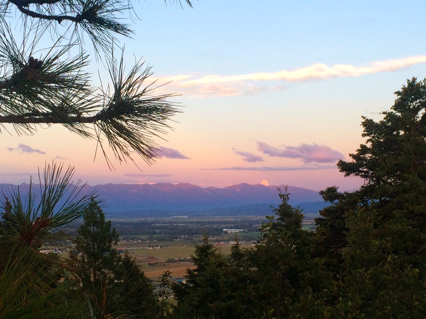
Last summer, I started watching the moon rise above the Swan too. And we put on a full moon hike at the park and invited everyone to come out to watch the moon rise with us. It turned out to be our most successful program at the park. I was so excited that I could describe all the peaks and point out where the moon would appear.
Watching the moon rise with more people that I ever dreamed would join us
Explaining where the moon rise would happen (as viewed from the park's overlook)
Hello moon. Right where I knew you would be.
Rising more.
Watching the moon come up between 6 Mile Mountain (that I’d climbed) and Big Hawk (where I’d been swimming last year) filled me with such joy.
View from the summit of 6 Mile Mountain.
Having those connections, especially in remembering that very first hike I’d led, where I hadn’t known any of this, makes me smile. I had no idea where that question would take me!
Summit of Mt. Aenes.
In thinking about moving, I wonder what new places will speak to me, and where my trips will lead. How do you find new places that make you want to know their every peak and valley? What modivates you to get out on your days off?

For more about my hikes in the Swan, links here.