Tuesday, May 16, 2017

Salt Creek

An overnight backpacking trip in the far southern corner of the Needles District of Canyonlands National Park with Still Waters.
Looking down into Salt Creek Canyon from Cathedral Butte Trailhead.
After descending a thousand feet, it's smooth walking on the Salt Creek Trail
Kirk’s Cabin build by a rancher in the 1890’s
Clear flowing water near Kirk's Cabin
While Still Waters hangs out in camp, I go on a ramble. Seeing Kirk Arch on the map, it seems a worthy destination. Just a mile from the trail up a side canyon. How long could it take? Probably just gone an hour, right? (This is what happens when I don’t read the reports ahead of time that this arch is “inaccessible.”)
Our campsite, SC1, had sprawling shade trees perfect for an afternoon nap
Scouting up and down the main trail showed no evidence of a social trail to the arch. The sheer, steep banks along Salt Creek prevented a direct route. Backtracking up and around the spring and through a jungle of sagebrush, meandering around sidewashes, and finally pulling on rainpants to provide protection from thick brush. Scrambling down the bank, bellycrawling up the other side, fingers clawing the dirt to gain a purchase. Wondering what the heck am I doing this for? Tiptoeing through the cryptobiotic soil and backtracking along slickrock and washes some more to avoid large patches of the fragile desert soils.
Finally reaching a wash below the arch, which provides some easy walking.
Two hours later, I am not even close to the arch. But I get to a high spot where I can convince myself I can’t go any further with my rock climbing/ scrambling skillset. If I had a decent camera with telefoto lens, I could have gotten a better photo from the trail and lounged around camp this whole time. Instead I am scratched up, hungry, and on my way to becoming one with the sand and dirt. Happy, in other words.
Turn around spot.
 But with only an hour to get back to camp before sunset and the time I’d told Still Waters I’d return, its a bit of a push. One of the problems with leaving as few footprints as possible is that it makes following my tracks back more difficult. I race to get back to camp feeling engaged with the landscape. With senses fully awake, the duskywings crusing up and down the wash come into focus and I spot a packrat scurring along a ledge at dusk (first time I’ve ever seen that!).
Also spot a lizard with bright blue markings. Might be a plateau fence lizard. 
I return to camp 5 minutes after the agreed upon time. Exhausted but completely satisfied. There is enough time to climb above camp for sunset watching and dinner. Still Waters gives me half of an avocado she packed in and I spread it on my tortilla and it is the most delicious thing I’ve ever tasted in my entire life.
Sunset watching spot above Kirk's Cabin.
This is Still Water’s first time cowboy camping, which is sleeping out under the stars instead of in a tent. I remember being scared about critters crawling on me the first time I cowboy camped. The next morning when I ask her how it was she says “It was like we are kids sleeping out in the backyard, pretending we are camping out in the wilderness.”

Which I think captures the essence of what I love most about sleeping out under the stars, and rambling bushwhacks— it feels like playing. Like being connected with the joy of the outdoors without the barriers of the tent, without fiddling with Fancy Gear, without having to follow some predefined path to get to somewhere in particular. Without having to be anything but ourselves.

More Information
Backcountry permits are required in Canyonlands National Park. Follow all backcountry regulations required to protect this fragile and very beautiful environment. We carried our food in a bear canister and packed out our poop.
Packing out my poop in a wag-bag.

Tuesday, May 2, 2017

La Sal Ramblings

Frozen ground and snow in the first stretch of trail. The air smells like the High Sierra in California or the Swan Range in Montana in late May. There’s the same crunch of my microspikes. The same grey-brown dirt still flat from the recently-retreating snow, sparse sprouts barely poking through the duff. The feel of higher altitude forcing me to slow down. At least some things are familiar.
Frozen/ thawing
Looking at the view from this high place out onto canyoncountry is like nothing I’ve seen in California or Montana, or anywhere else for that matter. The red rocks surrounding these La Sal Mountains are such a contrast. ISKY, Arches, the Needles, Hidden Valley and Moab, my familiar haunts these past three months— all spread out in clear view.
Redrock in the distance
On the side trip to Brumley Arch
Brumley Arch
The trail. It keeps disappearing under the snow. Where are you, trail? I backtrack, looking for cut logs. Above treeline, I look at the curve of the topography and imagine where the trail should go. Until I cease caring anymore and follow my own lines of curiosity.
Rambling on rocks
Down low near the springs, Milbert's tortiseshell are flitting about everywhere.
Little sprouts shooting up.  It’s frustrating, not knowing what it will all become. Back in Montana, back in Georgia, even further back in Maryland, I’d be able to recognize most plants just by the sprouts. Here, everything is a mystery that I may never solve.

Why am I’m spending so much time trying to learn the plants here anyway? I’m leaving in two weeks for my summer job.

Finally something recognizable. A blue bell! This I know from Georgia. Seeing it reminds how long it took in my previous homes to piece together an understanding of the local flora. Multiple seasons studying plants, excursions with the native plant society, hikes dedicated to finding plants at different times. Of course I can’t gain that depth of knowledge instantly. I shouldn’t feel so frustrated when the names get overwhelming and I feel like I’m lost in a sea of Latin and start to get a case of the I’m-not-smart-enoughs.
Bluebells
After setting up camp in the lee of a hill, low to be out of the wind, I climb up to a high spot. The La Sals glow with the fading light. I wonder what the high peaks will be like in another month, when I am far away. What if I never get up there? What if this is my last day ever in the La Sals. But maybe I will get another job here next season. I sent in my application last week. But who knows what will happen.
What will this look like when the snow melts?
Hoping this isn't my last sunset in the La Sals
Being up high provides much needed perspective. It makes me feel like I can see where I’ve come from. I see myself at 17, falling in love with the wide-open high desert starkness of Eastern Oregon during a summer field botany course at the Malheur Field Station. Visiting Arches and the La Sals in my early 20’s with my then-husband. A photo from that trip to the La Sals was the background photo on my computer all through grad school. A view of mountains when I was stuck in the lab. All these years later, being so filled with gratitude for keeping on a path that finally twisted and turned and led me here.
Photo from my first trip to the La Sals so many years ago.
The next morning before dawn, I pack up swiftly and climb high. Pulling my sleeping bag around me against the biting cold as I watch and wait. It’s not typical for me to not be on the move in the morning, but I long to stay in place here, even if just for an hour.
Watching the sunrise
In the crisp thin air, the important things are clear. I am grateful for the challenges of a new place that allow me to keep growing. Having a job that is meaningful and allows me to live in a stunningly beautiful place is such a priority for me that I can compromise on other things to make it happen. I know that I carry around within me everything I need to be happy wherever I go— the capacity to learn and to make connections. I am glad to have a heart that is open and allows me to feel so much even though it also hurts so much to leave. This is what is is to be alive— raw, intense, and vulnerable. Perched on a rock on the mesa below a snowcapped peaks pummeled by wind surrounded by fields of snow and mud. Cocconed in the warmth of my sleeping bag with belly full of instant oatmeal and peanut butter, creating enough heat to last until the sunlight touches me again.
First morning light on the La Sals
More Information
La Sal Mountains are the second highest range in Utah with 14 peaks over 12k feet. The Squaw Springs Trail #038 and Boren Mesa Trail #537 both lead from the Squaw Spring Trailhead and are part of the Trans-La Sal Trail. I explored to La Sal Pass to the south and then to Oowah Lake to the north on this solo backpacking trip.

Monday, May 1, 2017

Gaining a search image

Canyoncountry appears stark at first glance. In winter, the shrubs seemed too scrubby and impossible to tell apart. Almost (dare I say it)… boring. Most have small, nondescript leaves. Even cliffrose (Purshia), that produces creamy fragrant blossoms, appeared dull and inconspicuous.
Down into the canyon
But not anymore. Spring transformations are happening. And I’m hiking with a naturalist with years of experience in this area. Nothing is dull anymore.

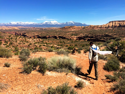
Up at the trailhead, Robb notices a cliffrose-like shrub, but this one has broader leaves and a spreading growth form. A different species?
Broader leaves of Pursha tridentata
Later, we find out it is Purshia tridentata, a close relative of P. mexicana, which is the one seen more commonly around Moab. If I were alone, I’d have overlooked it completely.
Pursha mexicana, the cliffrose commonly found around Moab
There is joy in hiking with someone who knows an area really well. When I was little, on days I as having a test my dad would always tell me, “Just sit next to the smart kid.” I never cheated on tests, but that advice became a life philosophy over the years, morphing into “make friends with the smart people, watch what they do, and learn from them.” It’s the ticket not to just learning facts, but learning how to learn and interact with this environment.

The trail tumbles down through the sheer Wingate Sandstone, like so many of my favorite hikes begin. Down below, there are some springs hidden beneath the ribbon of spring-green cottonwood that we are going to check out.

Robb’s butterfly net is slung over his shoulder and he periodically runs off chasing something I don’t see, returning to show me a treasure. “Look for green or brown triangles,” he says as he gently taps each cliffrose with the handle of his net and watches to see if it stirs up any butterflies. Looking for Desert Elfin, a species he’d not seen in this area previously.

Each species spotted is photographed and recorded in iNaturalist, an online, georeferenced tool for identification and sharing of natural history data. By the time we are done with the hike, other people have provided an identification for P. tridentata (which Robb entered into iNaturalist at the trailhead). What a helpful tool!

Soon, I’m staring to see the movement of tiny flittering creatures filling the canyon. I'm getting the search image down.
Plus a collared lizard
More shrubs are examined. Robb tells a story about blackbrush and how it is one of the oldest living things around. Blackbrush is low-growing and appeared to me all winter as even more boring than cliffrose. But learning how it could be hundreds of years old fills me with awe.
Down in the wash, the clear water girgles along and creates a deep pool lined by brilliant green algae.
As we climb back up, I marvel at how the butterflies come into focus, the birdsongs fill my ears, and how much more there is to see here than at first glance.

The next week while roving trail at my park, I spot a little brown triangle of my own, a Desert Elfin. And am grateful of for a newfound search image that makes a seemingly inconspicous world come to life.
So exciting to spot this Desert Elfin on the Devil's Garden Trail at Arches!