Saturday, December 29, 2012

Winter Wonderland at the Hike Inn

The second part of my winter vacation with my parents was 2-night trip to the Hike Inn.  I was thrilled to share this special place with my folks.  We got an early start the first day by staying overnight at Amicalola Falls State Park.  On the 5-mile hike to the Inn, we had clear views and saw a little snow on the ground.

On our second day, we set out on a dayhike on the Approach Trail towards Springer Mountain.  A mix of sleet and snow made the forest look incredibly beautiful.
My parents hiking in the ice.
A frigid wind was blowing hard at Nimblewill Gap, so we decided to turn around before getting to Springer.  I think I was probably the coldest, with my hands and feet frozen stiff.  Thankfully Dad gave me his mittens, which I layered over my own, finally feeling a bit better.  By the time we returned to the Hike Inn, it was snowing steadily, and we enjoyed soup and hot chocolate in the toasty dining hall.
Returning from our hike to the warmth of the Hike Inn.
One of my favorite things about staying at the Hike Inn is watching the sunrise while sipping hot drinks, so it was exciting that we had clear view on our last morning.
Delicious meals, especially the peach spoon bread.
The sun was finally out for our hike back down to Amicalola Falls State Park, but signs of the winter weather were everywhere.
Needle ice.
Needle ice formations were all along the trail.   They occur when the air is below freezing, but the soil and water in the soil is warmer than freezing.  The water at the surface freezes and pulls up more water via capillary action.
Beautiful ending to a wonderful trip.

Tuesday, December 25, 2012

Winter break at FDR State Park

My parents and I spent three nights over the Christmas holiday at FDR State Park, hiking parts of the Pine Mountain Trail.  This was my first time visiting this area, and we were all really impressed by the Pine Mountain Trail system's network of well-marked, interconnected trails.

After settling into our nice cabin overlooking the lake, my parents and I set out to explore the area.  Whenever I hike with my parents, I am always reminded where I get my hiking tendencies from.  In this case, we set out for a "brief stroll" on a paved road around the lake... 
My Dad and I at FDR State Park
But then a forest path beckoned, and we hopped on the rather muddy Delano Trail.  Signs pointed back to the cabin areas, but instead we took a turn down another trail, in the opposite direction.  And instead of going back via the trails, we headed down a powerline cut, then, following Dad, we set off cross country. 
Dad finds the "short cut" through the woods.
What had started out as a little walk escalated to a bushwack.  Now I know where I get this from!  The grande finale of the hike was that when my dad finally got to the road, he found $30 on the ground.   He's always picking up loose change, but this was quite a find!
Dad finds $30 on the shoulder of the road.
The next day, we set up a shuttle and hiked 5 miles on the Pine Mountain Trail from the TV tower trailhead to the Rocky Point Parking lot.   Though this is the most popular hike in the park, it was empty except for us because of the holiday and the rain.  Well-graded trail took us through a range of forest types, to scenic waterfalls, and past bright lichen-covered boulders.
Mom and Dad charging up the hills.
Dad and me on the Pine Mountain Trail.
On our last day, we hiked the 4.3 mile Dowdell Loop from Dowdell Knob parking area, highest point in the park and a favorite picnic spot of FDR.  This trail had nice open views, and a small creek and falls. 

Views created by the 2011 tornado
After the hike, we had time to visit the Little White House Historic Site and Museum.  I really enjoyed learning how FDR came to the Warm Springs pools and area to be treated for polio. Apparently, FDR was really influenced by his time in Georgia during the Great Depression, and his experiences here meeting farmers and other polio patients helped to influence his New Deal (which includes the CCC).   Since I've been a kid, our family has always taken vacations and spent our holidays, like this one, at parks and trails built by the CCC.   It was especially interesting learning more about the origin of this incredible program.

Saturday, December 22, 2012

Bartram Trail-- Courthouse Gap to Rabun Bald

My last remaining 0.5 mile section of the Bartram Trail in Georgia from Wilson Gap to the road crossing of FS 155 that I'd been too exhausted to finish last time had been nagging at me.  My New Year's Resolution of 2012 was to complete the Bartram, and on the second-shortest day of the year, I decided to give it another try.  This time, I started at another trailhead that I'd just found out about to give myself a better shot.

It was so early it was still partially dark when I set out at the Courthouse Gap Road parking area.  The short access trail (about half a mile) offered pretty views of Pinnacle Knob's rugged rock face, sparkling under a sheet of ice.

Turning north (left) on the Bartram Trail at Courthouse Gap, I hiked past Windy Gap, and then to FS 155, and then to Wilson Gap, completing the section I'd missed.  The 5 miles from Wilson Gap to Rabun were really stunning so I just kept going.
Ice on rocks north of Wilson Gap.
I pushed myself to move fast, aware of the limited daylight.   At Rabun Bald, second highest peak in Georgia,  I didn't linger long due to the cold wind, but turned around and hiked the 11 miles back to my car.  I was pleased set a new personal record for "hiking inefficiency"-- I'd done 22 miles in one day  to "complete" a 0.5 mile section.  Plus, I'd finally finished the GA Bartram Trail.

Friday, November 23, 2012

Thanksgiving in Hot Springs, NC

I spent Thanksgiving weekend section hiking the Appalachian Trail near Hot Springs, NC, including the spectacular trail across Max Patch.   Max Patch is a grassy bald that was cleared for farming and which is still maintained by the Forest Service.  Its 360-degree views make it one of the most scenic parts of the AT in the Southern Appalachians.

I stayed at the hiker-friendly Hostel at Laughing Heart Lodge, right on the AT.   A private, single room was $25/night, and the shared bathrooms, kitchen, and lounge areas were clean and comfortable, everything a hiker could want.  Glenda, the host at the hostel, was very sweet and helpful and I enjoyed my evening conversations with her.  Staying at the hostel provided a great base for three days of hiking along the AT.

Day 1. Lemon Gap to Hot Springs (14.4 miles)
From Lemon Gap (3550 feet), the trail climbed a mile up Walnut Mountain (4280 feet).  I hurried past the summit and took my first snack in the Walnut Mtn. Shelter out of the cold wind.
Open, grassy summit of Walnut Mountain
A few miles later, the wooded summit of Bluff Mountain (4686 feet) featured rock outcrops and good winter views.  The last six miles descended through some pretty pine forest and laurel, then opened into hardwoods on the final switchbacks into town.  It was so convenient to emerge out of the forest into town, and to find the first building I arrived at was my hostel.  What a great way to end a hike!

Day 2. Max Patch to Lemon Gap
In the early morning, it was a frigid 21 degrees and windy as I swooshed in my rainpants up Max Patch.  The wintery precipitation the night before coated the landscape in rime ice, giving everything a magical sparkle.  Dense fog made me grateful to be following the white blazes, otherwise it'd have been easy to get lost.  The place had a desolate feeling, like I was the only one around for miles. 
Lingering to admire ice formations for as long as I could bare the cold.
Bright horsenettle looks beautiful covered in ice.
Poor frozen butterfly.
Icicles dripping from my nose.
 The second time I arrived at Max Patch, the scene couldn't have been more different.  It was around noon, and the skies were blue. 
A few hours later, Max Patch under clear skies.
Climbing Max Patch (again) via the Buckeye Ridge Trail.
Frost still remained on the north slopes of Max Patch.
Gorgeous icy glaze.
I felt so grateful to have experienced this dramatic winter weather and to have seen this incredible place under such different conditions.

To top off my fantastic day, I went for an evening soak in the Hot Springs hot tubs along the French Broad River.  The hot water felt so good on my tired muscles after a long day of hiking.    

Day 3.  Tanyard Gap to Hot Springs (6.2 miles)
On my last day in Hot Springs, I did the short section of the AT north of town.  After crossing over the hiker bridge over the highway, the trail climbed to Mill Ridge, an old tobacco farm that has since been planted with wildlife-friendly plants. 
Pond below Mill Ridge
An informative sign at Pump Gap told how Boys Scouts treated the hemlocks in the grove with insecticides to kill the adelgids, saving the trees there for another few years.  The hemlocks there were especially lush.

The trail climbed again up to a ridge, which it followed for several miles.  The French Broad River could be heard roaring through the valley below.  
View of the French Broad River and town of Hot Springs from Lover's Leap.
From Lover's Leap, it was a steep rocky descent down to the river.  Then the trail passed directly through the center of town.
Fascinating history.
Following the signs for the AT through town and back to the hostel.

Sunday, November 18, 2012

Arkaquah Trail

Hiked with my friend JJ to Brasstown Bald via one of my favorite wintertime trails- the Arkaquah Trail from Track Rock Gap.  Calm and clear weather made for a lovely 12 mile round trip hike with exceptional views.
View from the summit of Brasstown Bald, highest point in Georgia.
Warm orange glow of fallen leaves.
Pausing to watch the sunset.
Headlamps supplement the moonlight on the walk down to the trailhead.

Sunday, November 4, 2012

BMT Sections 3, 4, & 5: Gossamer and Winter Views

Late fall is an especially beautiful time to hike in the north Georgia Mountains.  The winter views through mostly-bare trees were exception on this weekend's overnight backpack on the Benton Mackaye Trail sections 3, 4, and 5.

Shadows fall on the forest floor now that most of the leaves are gone.
The end of Section 5 follows the scenic Toccoa River.
Crossing the bridge over Little Skeenah Creek to begin Section 3.  Sporting blaze orange now that it's hunting season.
Lots of shimmering gossamer here.  But gossamer, like bigfoot, is difficult to capture on film, which is part of its magic.
Shimmering silver threads were waving in the gentle breeze.  My friends and I call it "gossamer", and it is seen when hiking into the sun when the low angle of light catches broken spiderwebs streaming from twigs.  To me, it signals the arrival of late fall.  In summer the same spiderwebs tangling my face are a source of frustration, but this time of year they are a source of delight.
Gossamer-maker
The climb up Wallalah Mountain in section 3 was especially steep but the views were worth the effort.
I tucked my hammock into the hillside below a fallen log to stay sheltered from the wind.
Since I camped down the hillside, in the evening, I hiked up to the ridge to watch the sunset.
Shadows advance across the mountaintops as the first golden rays of light hit the peaks.
The route:
Parked at Wilscot Gap (GA 60), and hiked BMT section 5 north to Shallowford Bridge.  Then got shuttled to Little Skeenah Creek (GA 60) and hiked sections 3 and 4 north to Wilscot Gap.  Got water at the signed spring north of Licklog Mountain (flowing very slowly, required going down pretty far), and camped about a half mile down the trail north of the spring.

Sunday, October 28, 2012

BMT Sections 9 & 10: Rain and more rain

My friend, Salt, and I went for an overnight backpacking trip of Sections 9 and 10 of the Benton Mackaye Trail in Georgia.   The forecast: 10% chance of rain. 
Trailhead at Dyer Gap
 There was light drizzle at the trailhead.  Wet fog passing through Watson Gap.  Mist at Mill Branch.
Grass of parnassus at Mill Branch, gone to seed.
More rain at Double Springs Gap at the Tennessee state lane where we turned around after getting water.

Thick, soupy fog and even more rain when we finally tucked our hammocks on a mid-elevation slope that seemed to be in the "wind shadow" of Big Frog.  The wind howled through the tops of the trees but only occasionally made it down to rustle the tarps. 

Can you guess what the next day brought?  Yep, more rain,  and tree foam!   Which is why the moral of this story is pack your rain gear no matter what the forecast.  I was glad I did.

Sunday, October 21, 2012

Duncan Ridge via the Coosa Trail

The next trail on my list is the Duncan Ridge Trail, considered the "toughest trail in Georgia."  I accessed the DRT via the 13 mile Coosa Backcountry Trail, which might sound totally inefficient, but that's just the type of thing I like to do.

After getting my permit at the visitor's center at Vogel State Park, I hiked clockwise on the Coosa Backcountry Trail, which shares tread with the Duncan Ridge Trail for three miles over Slaughter Mountain.   After spending so much time on the Bartram Trail wondering where all the people were, I can now report that all the people (or at least quite a bit of them) are at Vogel State Park. 

At the point where the DRT and Coosa Trail split, I took a little out-and-back trip on section 2 of the DRT.  I passed over Coosa Bald, descended to Whiteoak Stomp, and hiked for another hour, then turned around and returned to the Coosa Trail.  Not sure how far I got on the DRT but I'll find that out when I do the next section from the other trailhead.  Again, this was an unconventional way to tackle the DRT, but it allowed me to do the entire Coosa too.

Continuing on the Coosa Trail clockwise, I reached the end of the trail in early evening.  I hadn't expected to make it so far, and in retrospect I should have spent more time on the DRT, or at least not carried my full backpack the whole way.  I had to head back up the trail to find a stealth campsite, rather than camp near the trailhead. 

The next morning, I circled the Lake Trail, swung by the falls, then drove over to Yonah Mountain to scout that for a Trail Dames trip I'll help lead next month.  All in all my legs were sore by the end of the weekend, so it was a successful trip.

Lake Trail at Vogel State Park

Sunday, October 7, 2012

Hiking while sick

Do you still hike when you are sick?  I sure do.  As soon as I can drag myself out of bed, I head for a local trail.  There are some physical health benefits of exercise for a mild cold, but the biggest benefit for me is the mental boost.  Being stuck at home gets me down and depressed, and the only cure I know is some time outdoors and a little activity to give me a mental pick-me-up.  
Being near water always makes me feel better.
Sandy Creek Nature Center, just north of Athens, GA in Clarke County, has 4 miles of easy, interconnected trails, and is my usual destination when I'm too sick to go backpacking in the mountains.  I really like the Levee Trail that goes out to the confluence of the Sandy Creek and North Oconee River.  Boardwalks cross wet areas in the floodplains, but expect mud after rains.  Early morning is the best time to avoid runners and dogwalkers, and, as a bonus, the early morning light reflects off the water.
In the early 1900's, the Georgia Brick Company dredged clay from this site for bricks, creating this pond.
Tips for hiking when feeling under the weather:

    -Stay close to home.
    -Take it easy.  Keep your pulse rate down, your pack light, and your pace slow enough so you don't sweat.  Strenuous exercise can stress your body and prolongs recovery.
    -Stay hydrated and snack often.  Listen to your body. 
    -Rest often.  Find benches or fallen trees and lay down.  Or bring your hammock.  Watch birds and clouds, or take a nap.
  

Sunday, September 30, 2012

Bartram Trail-- Winding Stair Bridge to Cheoah Bald

I'd been planning my birthday backpacking trip for weeks:  finishing up my section hike of the Bartram Trail in NC by summiting the "grandstand of the Appalachians," Cheoah Bald.   I'd start the morning by going to trapeze practice (my other "favorite thing" in life), then climb 3000 feet up to the northern terminus of the Bartram Trail at Cheoah Bald, and then sleep out on the summit under the full moon.  Could it get any better than that?

I've been section hiking the Bartram Trail in NC since July, and totally fallen in love with this remote, peaceful, challenging, and well marked (and mapped) trail.  I had high expectations because this last section was described as the "grand finale" complete with waterfalls and panoramic views, which I recalled from when I'd previously hiked the AT over Cheoah Bald on a clear day last November. 

I arrived at Winding Stairs Bridge Parking area off US 19/74 in late afternoon.  High on trapeze endorphins and birthday cake, I sailed up out of Nantahala Gorge admiring the first fall color.  Climbing 3000 feet sounds really tough, but I felt as if I could fly. 
Looking across Nantahala Gorge to the "surge tank" where I'd passed a few weeks ago
Occasional rain made fallen leaves and rocks slippery, and this technical footing required concentration and caution.  But the rain also made the forest smell sweeter, the leaves glisten, and brought out little creatures.
Wet leaves over slippery loose rocks
Salamanders come out to play in the rain
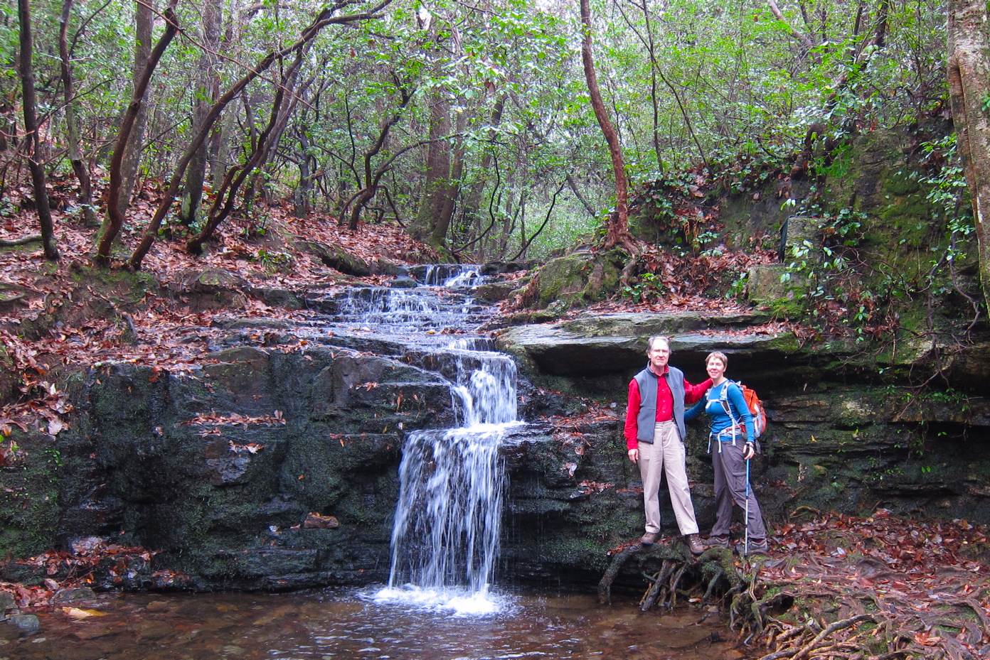
The trail crisscrosses Ledbetter Creek for several miles as it cascades through a steep narrow valley and goes over a long series of falls.  Impressive rock walls echoed the sounds of the rushing water.
Lovely, several tiered Bartram Falls drops over 50 feet
All the way up at its headwaters, Ledbetter Creek is small enough to easily step across.
Dressed in my pink long underwear and new DIY gaiters that I sewed especially for the Bartram Trail
The Bartram crosses FS 259 road near a spring lined with flowers.  I checked my map and realized I was only 0.9 miles away from the summit, and I couldn't believe it!  I was almost there!
monkshood at the spring
The climbing continued in earnest before reaching the "knife-edge" ridge.  Then, it was time to cruise and enjoy the ferns, mosses and stunted trees and listen to the wind howling.

Fog was moving across Cheoah Bald when I arrived.  My dream had been to watch the sunset from the bald and see mountains awash in fall colors, not to be socked in with fog!  What do you do when you finally reach the exciting climax of a long journey, and then it does not go according to plan!?!?

First I waited.  As I watched, the landscape became more breathtaking to me than anything I could have dreamed.  The silhouettes of trees stood out dramatically in the swirling fog.  For a few moments, the clouds shifted to reveal the surrounding mountaintops. 
Fog on Cheoah Bald
Next, I explored the bald, crisscrossing up and down the deer paths through the field of flowers.  This incredibly botanically rich area is a designated "mountain treasure" with rare plants and an abundance of goldenrod and asters, and shimmering candelabras of gentians.  The soft light brought out the vibrant colors.

When it got dark and I zipped into my hammock, the clouds were still thick.  Since it was only 8 PM, I put in my headphones and started listening to podcasts.  One story in particular spoke to me. A woman and her father trek for several days up to Everest Base Camp-- only to discover there is no view of Everest because of (you guess it!) THE FOG.  In the story, the clouds eventually part, but only after the father and daughter talk about the importance of enjoying the journey itself. I drifted to sleep thinking how universal this story is, and feeling so happy to be just be enjoying the trip.
Hanging at the edge of Cheoah Bald
A bright light woke me around midnight.  Scurrying out of my hammock, I looked up and it was the full moon!  Incredibly, the clouds had parted and the entire bald was illuminated.  I could see the soft moonlit peaks of mountains extending outward for miles and miles.  How lucky to be out there basking in that glow!
Full moon and the end to a wonderful birthday and trail!