Saturday, December 31, 2016

Reflections on 2016

Life continued to follow a different path following my 2014 Pacific Crest Trail hike.
Highlights of the year— first job at a national monument, returning to Montana for a second AmeriCorps term at a state park, and returning to the PCT for a month-long section hike-- were all things I never though I'd be doing before the PCT.
Plus volunteering at this national mounument in Colorodo at the end of the year
After the PCT, I switched from doing scientific research to interpretation and outdoor education. This year I really appreciated living in beautiful locations, doing work that felt like it made a difference, and having the opportunity to learn new skills.
Planting trees in Montana
Teaching about the water cycle
What I loved about working in parks
Because I lived in parks while I was working, my daily walks through incredible scenery were as captivating to me as my weekend trips. Even if it was three months of the same two miles.
Evening stroll around the park I was at in New Mexico
My mornings in Montana often included watching the sunrise from the park's overlook
Because I lived in beautiful regions of the country, my weekend trips provided easy access to spectacular locations. In New Mexico, El Malpais National Monument and Petrified Forest National Park became new favorites. In Montana, I continued to volunteer on loon and mountain goat surveys for Glacier National Park’s citizen science program. Despite my initial fear of grizzlies, I came to love Montana.
Mountain goat survey in Glacier National Park
Another thing I finally did this year was take a 72 hour Wilderness First Responder course. A few experiences made me realize I need more background in how to respond to medical emergencies and accidents, so I’m really glad I’ve finally gotten more training.

But there were downsides to living the dream

A lot of moving meant the sadness of leaving friends. Will moving ever get easier?

The No New Gear experiment helped me not dip into my savings with the low AmeriCorps stipend. But I wish I could not be so nervous about my bank account and my future job prospects.

Things got pretty busy this year. Looking back over my photos, I realized just how many trips I didn’t have the energy to write up.
One hike in Glacier that never made the blog
 The line between work and play was often blurred. Many early mornings were spent taking wildflower photos for the wildflower identification posters and guide I made for my state park. This was a project I’ve been dreaming of doing for years (even before I got to Montana) and allowed me to learn more about a favorite topic (plants!). Sometimes I'd wonder, why am I doing this? And then I'd remember, because this is what makes my life seem meaningful and fulfilling-- especially seeing visitors come to the center to ask me about plants or show me photos they'd taken of what'd been blooming.

Backpacking on the CDT and PCT with friends
Even though I moved a lot, one great thing was that my hiking buddies came out to visit me (in Glacier and New Mexico) and met up with me (in Washington and Oregon on the PCT). Despite having my highest mile day ever this year (30 miles to Mt. Taylor), the majority of my trips this year prioritized exploring the natural world, being with friends, and lollygaging (i.e. swimming in lakes and just sitting and watching).
Me and Jan on the PCT in Washington
This approach allowed me to avoid injury and I feel like it was a good balance to the hectic pace of working in parks. What I really wanted to do was connect with friends and really have a sense of place.
On the PCT in Oregon with Renee
What’s next

I’m moving yet again next week to start at another park. Hopefully I'll be able to talk a few friends into visiting again and hiking with me (hint- this means you!).

Finally thanks to all of you for reading and commenting on the blog! Really appreciate your support.

Thursday, December 29, 2016

Bears Ears National Monument

President Obama declared Bears Ears a National Monument yesterday! As someone who has hiked in this area and who cares about protecting valuable cultural and historical resources for future generations, I'm thrilled this finally happened.
Bears Ears Buttes, as seen from Natural Bridges National Monument (where I camped last month.) The newly established Bears Ears National Monument surrounds the existing Natural Bridges National Monument.
Bears Ears National Monument includes a wealth of American Indian cultural sites and thousands of years of human history. It’s like an outdoor museum, inviting exploration and wonder, but also has been hit hard by vandalism and looting and part of it was even sold off earlier this year. That's why protecting it now as a national monument is such a big deal (read the eloquent presidential proclamation here and see the map of the area here).

Many people have been pushing for Bears Ears to be made a National Monument including a coalition of tribes who have sacred sites here and trace their ancestral homes here. One thing that is unique about this National Monument designation is that American Indian tribes petitioned the President to create the Monument and that it includes establishment of a Bears Ears Commission made up of tribal members that help to manage the area for the future.
Sign at Natural Bridges about the significance of the butte.
Last month, I visited Comb Ridge (part of the area that is within the new monument) with an member of a local archeology group who has been visiting this area for many years. We hiked up to an Ancestral Puebloan site and petroglyph panel and she pointed out a lot of things I hadn't noticed when I'd visited here before. She says that since she started coming here, she has noticed a big impact- there are fewer and fewer pottery sherds for example.
Ancestral Puebloan site on Comb Ridge that we visited in November of 2016. This site is now protected!
Sherds like this one used to be more abundant. Sherds contain a wealth of information about the lives of the people who lived here- including when they were here, the history of trade, and even what they ate and drank. Loosing these artifacts robs these places of pieces of their history.
Corn was farmed by the people who lived here. It's amazing to see this after hundreds of years. I hope future generations also get a chance to hold pieces of the past like this.
The establishment of Bears Ears as a national monument has been controversial due to arguments about development of mineral rights and also resistance to federal lands (read more about that here). It is possible that the Antiquities Act of 1906 will be challenged in the coming years. So be sure to stay current on this issue and make your voice heard.
Climbing up Comb Ridge, now part of Bears Ears National Mounument.
No trails here, so you're free to explore.
View from the top of Comb Ridge.
Want to see more photos from this area?

In 2015, Jan and I spent a few weeks traveling around Comb Ridge, Valley of the Gods, and Cedar Mesa, all areas that are now protected now as part of Bears Ears National Monument. 

Read Jan’s trip report too.
Ending this with paintbrush, which was still blooming in November.

Monday, December 26, 2016

Rock Creek in Canyons of the Ancients

I’d somehow gotten the impression that there was nothing to see in Rock Creek and East Rock Creek trails (in Canyons of the Ancients National Monument, Colorado). Maybe because adjacent Sand Canyon is dramatic/ exciting with numerous Ancestral Puebloan sites. So I’d never bothered.
Until this unseasonably warm day in December.
The trail begins by heading west over to the canyon mouth filled with cottonwood trees. Lovely trees! Two are perfectly spaced for a hammock. Doesn’t matter that I don’t have my hammock along or that camping isn’t allowed here. My brain is wired to constantly seeks tree-homes. Unfortunately, the trail doesn’t go down for a closer look, but it doesn’t matter I’ve already got that relaxed feeling of safety in knowing the trees are there.
Sandstone walls rise steeply. A long view up the canyon beckons.
Continuing on, there are patches of snow. Some of the snow is round and not really snow but this other thing called graupel. Graupel is ice surrounding a snowflake. I had no idea this type of precipitation even existed until one of the rangers pointed it out the other week. Now I see it everywhere.
Graupel in a strange formation
Near some graupel is a dead mourning cloak butterfly. Mourning cloaks usually emerge from hibernation in late winter, at least they do in Maryland and Georgia where my hiking buddies and I eagerly anticipated the first sighting signaling the change of seasons. Not sure what is normal around here, mourning cloak-wise. Did this one came out early on a warm day and then got caught in the storm?  Like Bumpus’ house sparrows?
What happend to the mourning cloak?
A bit up the canyon, the junipers are larger, with twisting thick trunks. A few well-spaced trees too. The canyon walls look stunning up ahead but instead the trail crosses the wash and circles back rather abruptly. In this part of the Canyons of the Ancients, you gotta stick to the trail. So out come the binoculars and I sit and see what there is to see by staying still.

Do you carry binoculars? If you don’t and are still trapped in the lightweight mentality like I was for so many years, I’m sorry. Maybe give it a try and you’ll see.
Scanning the landscape with binoculars and reading the guide to the area.
The tunnel vision provided by binoculars helps block out unimportant things (like mental chatter.) I focus in on rocks, bushes, cliff-faces and more rocks. No apparent petroglyphs or Ancestral Puebloan rock walls visible here. Wrong exposure? Wrong geological formations? Too far from water?

But there is a rock that looks like a goat! A goat-rock! I haven’t seen a goat-rock since I left Montana. I watch for a while. It doesn’t move. I scan around with my binoculars, then focus back on the goat-rock, just to check. Still not moving.

I learned about goat-rocks while doing mountain goat surveys in Glacier National Park for their citizen science program. Goat-rocks are rocks that look like mountain goats but don’t move and can’t be counted in your survey (because they aren’t really goats.)  But sometimes you can stare at them for a long time and they suddenly start moving around and you realize they are really rock-goats, which are real mountain goats that look like rocks. You get to count those on your survey form which is nice because it’s fun to count things.
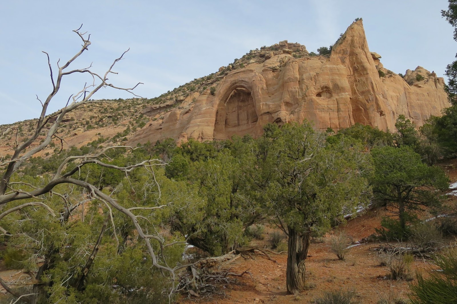
An arch near the mouth of the canyon.
Out here in the Four Corners area, there are apparently desert bighorn sheep to be spotted but I haven't seen any and don't know where to look yet and don't think there are any around in this area. For now, at least the rocks provide something to look at.

Continuing down-canyon, scanning the cliffs with binoculars finally reveals a few Ancestral Puebloan sites tucked away. This week, I’ve been reading articles and a book about the Sand Canyon Archeological project. The section on "macrobotanical remains" details the plants and trees used at each site-- so you can find out what what tree species were used as roof timbers (tree-home links being of utmost interst!). The more I learn about the archeological methods that give insights about the everyday lives of these people and how they interacted with people from the other areas around here, the more questions arise and the more I wonder.
Scanning each layer of rock
Maybe feeling at home in a new place is about with having enough questions rattling around in one’s brain about an area to keep it engaging. Guess that process takes time and focused study. And keeping one's eyes open. This hike feels like a step in the right direction.

Trail Information
Canyons of the Ancients National Monument

Thursday, December 22, 2016

Winter Solstice

Mancos Canyon in the Ute Mountain Tribal Park in southwestern Colorado holds several sun calendars that mark the solstices. Our special winter solstice tour took us to see these unique petroglyphs.
Heading into Mancos Canyon
The Sun Field petroglyph has five spirals above a grid (interpreted to be agricultural fields) with five marks below. We watched the shadow creeping across it, connecting each spiral with a tickmark. It’s really something to imagine people back in 500-700 AD standing here, watching this same thing we can see now on this same day.
To find the Sun Field, look at the triangle in the center
Sun Field- after scrambling up to get a closer look
 The Ute Mountain Tribal Park is adjacent to Mesa Verde National Park, but far less visited because you can only go there with a guide. The difference between this area and the surrounding areas is astonishing. Seeing all the pottery sherds remaining on the surface at the Red Pottery site, for example, made me realize just how picked over/ vandalized other sites in the area are.
Thiis mound is part of a very large site, probably an administrative center.
Our guide is an archeologist who has been studying this area for decades. We walk around and look at the diversity of the pottery sherds.
Pottery sherds- so much information contained in these beautiful pieces of the past
Many in our group (actually, I think it is everyone but me) know how to identify Ancestral Puebloan pottery types and can recognize the diagnostic features and what period they came from. Someone holds up a sherd with special decorations on both side and identifies it as being made between 1260-1270 AD.

The Butterfly panel is a series of petroglyphs that have been interpreted by the Hopi (the descendants of the Ancestral Puebloans who lived here) to tell the creation story and the story of the emergence of the people. The point of the shadow moves across the panel, intersecting particular parts of the figures and going beneath other figures. We all listen to the story, and then the sun goes behind a cloud and everything becomes ordinary again. We wait and wander around and look at the sky some more.
Butterfly Panel
Then the sun emerges and the shadow casts its shadow once again, so stark and dramatic.

It feels good to mark the solstice by learning about these ancient people and walking where they did so long ago. These short days, and all the darkness, are hard. I’m looking forward to more light.


More Information

Ute Mountain Tribal Park has regular tours too. I'm usually reluctant to pay for tours, but this was one of the best $20 I've spent in a long time.
http://www.utemountaintribalpark.info/

Thursday, December 8, 2016

Through the canyons

Sand Canyon is the only part of Canyons of the Ancients National Monument (in southwest Colorado) where you have to stick to the designated trail. But that’s OK. There are plenty of other places for rambling off elsewhere. This is one of the more popular areas in the Monument, so staying on trail helps protect it.
Ancestral Puebloans built this.
Small signs point the way to “spurs” off the main route. They don’t say what you will find and the map doesn’t show the locations of the sites. It's up to you to keep your eyes open and see what there is to see. It's up to you to choose to take the side trails.  It's good practice for long trails where sometimes it's hard to remember to take the turns off the main path. (Hint: always take the side trails.)
What will be around the next bend?
I’ve hiked this trail a few times over the years but it is the first time I spot a cliff dwelling on the other side of the canyon. With it being so quiet here now, it is easy to forget that 800 years ago there were many people living throughout this area. But evidence of their presence is here if you know how to look carefully.
Way over there.
Anything up there?
Over here.
Another thing I do find is poop. I assume it is dog poop because it is carefully wrapped up in little doggie bag and standing by the trail. (Why do people do this?) It's still smelly and gross and no one is around. Maybe I can just walk past and pretend I didn't notice it?

But then I remember I have my "Junior Ranger" patch on my pack, so I can't just leave it... because, you know, the junior ranger oath. And cause I've started volunteering here so I'm caring more about this place as I learn more about it, and also most importantly, cause it's the right thing to do.
Double bagging the dog poop to carry it out.
The snow has had a few days to melt. But it still hangs on tight to the north-facing slopes.
More snow.
More melting.
Beyond the “Most difficult/  Next mile is Rocky and Steep” sign, the ratio of animal to human prints improves. Eventually, there are just two humans that have passed this way in the last few days.

The switchbacks tightly zigzag up a sunny slope through boulders.
Almost to the rim.
At the top, I sit on the canyon rim feeling the warmth of the sun. The air is so still. The silence is so large.

Ravens circle, then swoop above. Their shadows dance along the rocks.

Thank goodness there are still places to find this much silence.

More info

Sand Canyon Trail is 6.5 miles one way from the lower trailhead to Sand Canyon Pueblo. My app calculated that with all the spurs and exploring around Sand Canyon Pueblo the total mileage was 14.5ish miles.

Stop by the Anasazi Heritage Center before you go to visit the museum and pick up the trail guide.

This trail can be popular so arrive early because parking is limited. Or go during the dead of winter during the week and see no one (like I did).

No matter what, respect this place and do your part to preserve it for future generations. Stick to the trails to avoid creating confusing social trails and to avoid killing the delicate cryptobiotic soil crust. Leave all artifacts where you find them.
Sleeping Ute.

Saturday, November 26, 2016

Arizona Trail- Going home

Waking up to the sound of rain. How do other people keep their stuff dry while getting in and out of a tent in the rain? It’s so easy under a tarp with the hammock. I miss my hammock. It seemed like it would be fun to master another system. But the reality is that I don’t want to have to think about gear.

The rain stops once I’m ready to pack up. The sun paints pinks and purples on passing clouds.
At the top of the ridge, I have enough signal to get the forecast. Possible thunderstorms and high chance of rain. What would that be like out here?
What does "possible thunderstorms" even mean?
How much rain does it take for a flash flood to happen? More than a half an inch? But what about the "heavy rainfall" part? Does that make a flash flood? Will the new tent keep me dry in "heavy rainfall"? I just don't have a good feeling about any of this.

I call Still Waters. “Does it make me a quitter if I get a ride to my car?”

I hear the tone in her voice change. She has this way of sighing when I talk about being a quitter.

“Just make smart decisions,” she says.

I hike the mile back down to the highway. I will get a ride to my car.

When I get to the road, the idea of hitchhiking fills me with trepidation. Which is werid because I've never had problems getting a ride. But it is right after the election and the world seems less safe- so many hate crimes exploding in the news. Of course nothing has really changed— there are still the same people everywhere and I am still the same person. A person who can get rides from strangers.
I take a selfie just to double check. You'd pick me up, right? Is the short hair is a little suspicious? Maybe the “Junior Ranger” patch on my backpack wasn’t such a good idea.
But then I get over myself. I find a wide spot in the road, adjust my attitude, smile, and stick out my thumb.

A car passes. There is so little traffic that I can sit down between cars. Another car. Another.

The thing about hitchhiking is that you just have to wait for the right person to stop. You don’t even have to believe in the universal kindness of humanity. There just has to be one person. Turns out she isn’t even going my way. She passes by and I see the “Arizona Trail Association” sticker on her car and she stops and turns around.

“This isn’t a good place to be," she says. "Hop in and I’ll take you down the road where you can wait. If you can’t find a ride by the end of the day, call me and I’ll take you to your car.”

The ladies at the gas station where I get dropped off tell me I can’t hitchhike here- “It’s too dangerous.” Then an older guy stops in (who they know) and the ladies arrange for him to take me to the Roosevelt Lake Resort.

I have no idea why this will help me get to where I’m going. But they insist. I trust them.

Families are sitting around the lodge having breakfast when I walk in. There is a fire in the fireplace and the smell of hot coffee and bacon. The manager tells me that he is heading into town in an hour with his son and they are going right past my car! Would I like a ride to my car with them?

YES!

How could things have worked out so well?!?! I can hardly believe it but I am to my car in such a short time and on the road and driving all the way back home.

The next day I sit inside drinking hot cocoa and look out the window as the most intense hail storm I’ve ever seen moves through. It’s so loud and covers the streets with an icy mess. Is this happening down on the Arizona Trail? I don’t know but when I check the weather I see there is lightening strikes out there and I am glad I am not out in it and I am so very thankful for all the good people who helped me along my way. Those three people that gave me rides (three!) restored my faith in human kindness once again. It warms my heart to know there are still good people out there who will help out a stranger.

Maybe I needed to know that more than anything else right now.

Friday, November 25, 2016

Arizona Trail- Passage 20- Four Peaks Wilderness

Shake Spring to Cottonwood Creek
21.6 miles

Hiking in the dark of early morning. Not even a speck of glow on the horizon. My weak headlamp is worthless so I turn it off. Moonlight is more than enough to show the trail ahead.

It’s pure joy to be walking in the predawn. In Montana, I always waited until daylight because of the grizzlies. I’ve missed this— the sounds and scents intensified, the feel of trail underfoot, seeing the first signs of pink on the horizon. Watching the light slowly changing into morning.
Crossing scree fields by first morning light
I’m glad I had the experience of hiking in grizzly country though, don’t get me wrong. But I’m glad I can hike here now in the dark.  Appreciating this hour all the more. Maybe that is how it will be with the tent. Maybe?
Contouring along the hillside
Watching shadows
The Four Peaks Wilderness is everything I love about a remote place. Being a tiny speck clinging to steep slopes. No sounds of cars. No people.
Four Peaks Wilderness
By mid-day, it heats up like summer. The sun umbrella comes out. Still hot. Careful attention is placed on water— consumption rates, how much is left. Small sips of water, swirled around before swallowing. No gulping. Gotta last.
Saguaro
A sliver of shade from a spiny desert bush. I plop down. My back is drenched in sweat. I can’t remember being this hot for a long time. Maybe there was one hot day in Montana this year but I was working and missed it. Funny to finally find summer this late in November. Guess that’s Arizona for you.

The break doesn’t last long. Must get to the water cache by evening. There is no water at Granite Spring. There is no water at Buckhorn Creek. Walking amidst the towering saguaro cactus and gazing down at Roosevelt Lake, imagining how it would feel to gulp water, to swim in a lake. My gallon of water is wedged under a rock up ahead. Cool water waiting.
Lots of water down there.
The trail is narrow and the loose rocks make footing difficult. My feet slip and slide like I’m walking over marbles. I look at my watch and frown, disappointed I’m not making better time. Must beat the sunset. But also— must not slip and fall.

Humans! The first (and only) humans encountered this trip are an AmeriCorps/ American Conservation Experience (ACE) crew doing trail maintenance. ACE is the AmeriCorps program here in Arizona that provides opportunities for young people to do environmental stewardship projects. It’s the local equivalent of Montana Conservation Corps, which is a group I worked with at my park in Montana.
ACE crew and the beautiful new tread
I’m the first hiker the crew has seen up here and I have the privilege of being the first to hike down the improved trail. They’ve smoothed it out, created waterbars, and widened it considerably. Amazing work! Thank you for making the Arizona Trail a better trail and for your service!

In no time I’m down at the road, retrieving my water cache, trucks whizzing by as I cling to the side of the road crossing the bridge.

There is water in the cattle tank too, so my water cache was unnecessary. But it meant I got water 2 miles sooner. Two miles of blissful hydration.
Water
Checking the weather forecast brings bad news. Now it says heavy rains and possible thunderstorms. Maybe a little water would be good to fill up the springs. But maybe there would be too much water in the form of flash flooding.
Tent
The trees along Sycamore Creek have sprawling branches and most of the ground is slanted. More hammock sites than tent sites here. I find a spot but can’t get comfortable.

 My body aches and I just want to sleep but instead I just toss and turn and think about flash floods and lightening on exposed ridges and slippery trails and being alone. Nights are long this time of year. Too much time to think.